Richard Sourbès, Impact Officer for Reforest'Action, is responsible for monitoring and measuring impact using remote sensing and geomatics (GIS) tools. He explains the needs met by these tools and what they bring to the design of our forest and agroforestry ecosystem restoration projects, as well as to the monitoring of their results.
How is impact management a cornerstone of Reforest'Action's activities?
Richard Sourbès : Scientific and technological innovations, such as satellite tracking and artificial intelligence, are opening up new perspectives to support the development of forestry and agroforestry ecosystem restoration projects. Since 2021, Reforest'Action has been conducting research to develop an information and data analysis system around our projects and their impacts. This system, based in particular on remote sensing and geomatics, is crucial to increasing the efficiency of our activities and bringing transparency to the investors who fund our projects. It aims to guide both the design and the monitoring and evaluation of our projects' results over the long term.
How do remote sensing and geomatics (GIS) fit together?
Richard Sourbès : Remote sensing uses raster data acquired remotely by spaceborne sensors (satellites) or airborne sensors (drones) to analyze the physico-chemical characteristics of land surfaces across a range of spectral bands.
Geomatics, or geographic information systems (GIS), combine cartography, computer science and statistical analysis to process vector data, i.e. georeferenced data (characterized by GPS coordinates).
At Reforest'Action, these two disciplines are used in complementary ways. Remote sensing provides us with satellite images overlaid with GIS databases, such as topographic and hydrographic data. Combined, remote sensing images and GIS databases enable us to carry out high-quality geospatial analyses.
How does geospatial analysis play a part in the design phase of a project?
Richard Sourbès : Before a project is implemented, a study is carried out to analyze its priorities and constraints, as well as its suitability for our specifications or for certification to an international carbon standard. Data analysis by Reforest'Action's Impact Department begins with this preliminary study.
In particular, we analyze the landscape matrix of the project area using satellite images and geospatial databases, to estimate land cover typology, soil composition and relief. We also carry out a risk analysis to determine whether the project area is prone to deforestation, fire or flooding.
In this phase, we produce a number of maps, the analysis of which enables us to contextualize the project and gain a better understanding of the issues specific to its ecosystem typology. By overlaying the maps obtained, we can then estimate the high-potential areas in which we can develop our project.
How can geospatial analysis be used to guide field monitoring of the health of restored ecosystems?
Richard Sourbès : Prior to the monitoring missions carried out by Reforest'Action in the field during the first five years of the project, the sample plots to be audited can be defined using satellite images, which are analyzed to produce a stratification of the project. This involves dividing the project area into several sub-plots that are homogeneous in terms of project design, vegetation types and topography. This stratification process is then used to set up an operational monitoring system that reflects the reality of the project as objectively as possible.
Remote sensing is also used to assess forest ecosystem health from a distance, before verifying it in the field. Analysis of the vegetation moisture content index (Normalized Difference Moisture Index - NDMI) and biomass density index (Normalized Difference Vegetation Index - NDVI) provides an overview of vegetation vigour in the project area, and identifies potential malfunctions, such as water stress.
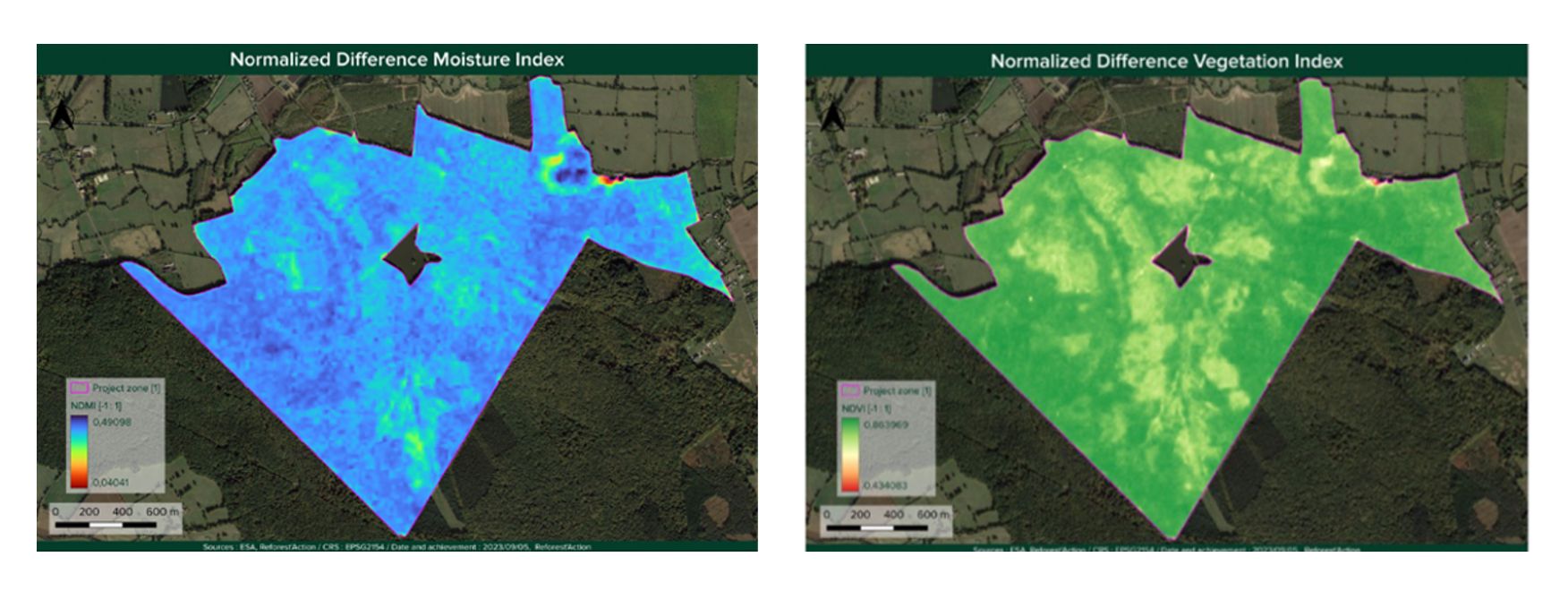
Field missions, guided by this analysis, will then aim to explore areas identified remotely as being in a potential state of stress, but also those that appear healthier, in order to better understand the ecosystem characteristics at the root of this differential.
These tools enable us to better monitor the progress of our projects, optimize field follow-up missions and suggest corrective measures as soon as a negative trend is detected.
How can remote sensing be used to assess plant diversity within a forest ecosystem?
Richard Sourbès : In collaboration with The Global Biodiversity Standard, Reforest'Action has developed a method and tools dedicated to mapping tree species diversity within canopies, based on a concept by J.-B. Féret and G. P. Asner. These tools are fed by satellite images. They allow us to evaluate, by proxy, the biological diversity of canopy species within a given plot, by grouping them into categories called “spectral species” according to their physical and biochemical properties. Using remote sensing, we can thus measure the evolution of forest diversity within a project area over time.
How can the spectral species method better integrate plant biodiversity into forest management?
Richard Sourbès : This method and its associated tools are invaluable for forest management and restoration projects. The georeferenced data obtained can be used to deliver an initial diagnosis of canopy plant biodiversity at forest scale, to better understand the ecological and environmental factors that promote or hinder this diversity, to establish good practices that lead to high diversity, or to adopt corrective measures in the opposite case. Forest managers can then draw on this data to develop their management practices in order to optimize species diversity, as well as the stability and resilience of the forest ecosystem as a whole.