Our impact management tools
Technology and field expertise for restoration projects
To accelerate and extend the implementation of high-quality Nature-based Solutions (NbS), robust tools are needed to monitor the stability and health of ecosystems, as well as their impacts on the environment and populations. Reforest'Action's Impact Unit relies in particular on modeling, remote sensing and geomatics (GIS) to prepare, reinforce or complement monitoring carried out in the field, as part of a solid process for assessing the stability of restored forest and agroforestry ecosystems, and the impacts they generate.
Projection tools to put impact at the heart of project design
Projection tools are based on data analysis and modeling. Their purpose is to :
- assess the quality of the project's design, taking into account its context and the needs and capabilities of the project owner.
- suggest, where relevant, areas for improvement in project design.
- provide companies with a quantified impact estimate prior to project implementation.
Climate
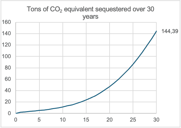
Tool for estimating the carbon storage potential of each project in terms of tonnes of CO2 equivalent sequestered over 30 years. Tool and methodology developed by Reforest'Action and validated by Bureau Veritas.
Biodiversity
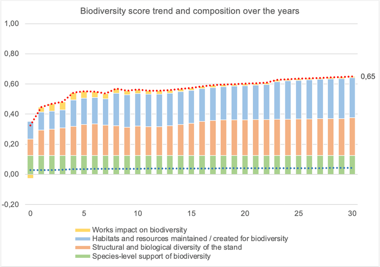
Tool for assessing the restoration of biodiversity carrying capacity, through the structural and biological characteristics of the project ecosystem. Developed by Reforest'Action on the recommendations of the Royal Botanic Gardens, Kew.
Ecosystem stability
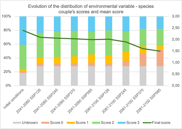
Tool for estimating the level of adaptation of the species supported by the project to current and future topographical, pedological and climatic conditions. Developed by Reforest'Action and based on work by CIFOR-ICRAF.
Water
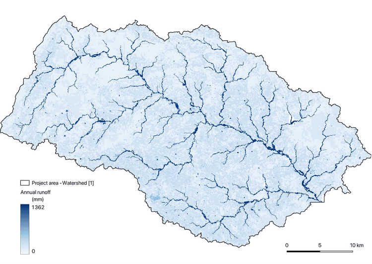
In order to model the quantity of water infiltrated and the quantity of water runoff on an ecosystem scale, and to project the evolution of these metrics after the implementation of a project, Reforest'Action uses the VWBA (Volumetric Water Benefit Accounting) model developed by the World Resources Institute, and relies on the Invest tool. This tool illustrates the circulation of water within a watershed, and provides a map of water flows. It is then possible to model the landscape after project implementation, obtaining spatialized data for three impact projection indicators: evapotranspiration, avoided runoff and local groundwater recharge in millimeters (mm).
Remote sensing for exhaustive and frequent examination of the project and its area of influence
Remote sensing and geomatics enable projects to be monitored remotely, regularly (once or several times a year) and exhaustively (over their entire surface area and zone of influence). These technologies are used to define the project context, analyze risks, monitor ecosystem health and assess impacts. The results provide spatial and temporal trends, which are used to frame field missions (for example, targeting an area showing water stress).
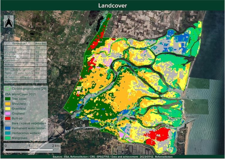
Geospatial analysis
Study of satellite images and geospatial databases to contextualize the project and better understand the issues and risks specific to its ecosystem and location (land use and occupancy, topography, fire risks, risks associated with sea-level rise, etc.).
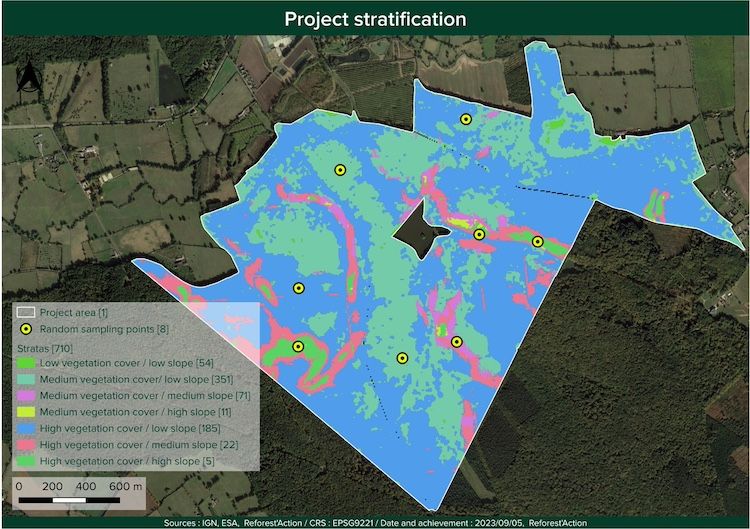
Stratification
Definition of the plots to be monitored remotely and in the field. To ensure that they are representative, a geospatial study, combined with the project's design elements, enables the project to be subdivided into homogeneous zones.
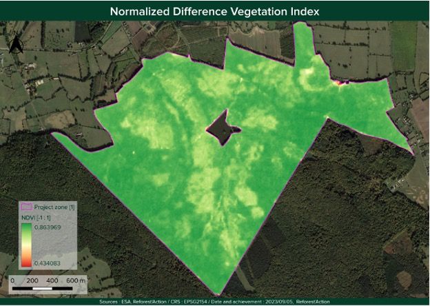
Ecosystem health
Analysis of NDVI and NDMI indices to assess vegetation vigor through photosynthetic activity, and detect any areas of water stress.
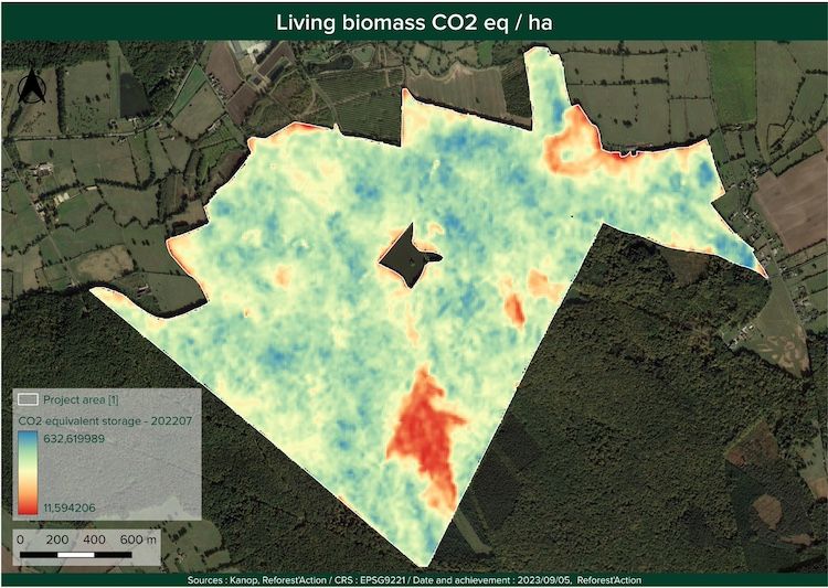
Carbon sequestration
Remote sensing study to assess carbon content in living biomass (above and below ground) and deduce sequestration in CO2 equivalent in the forest stand.
Vegetation diversity
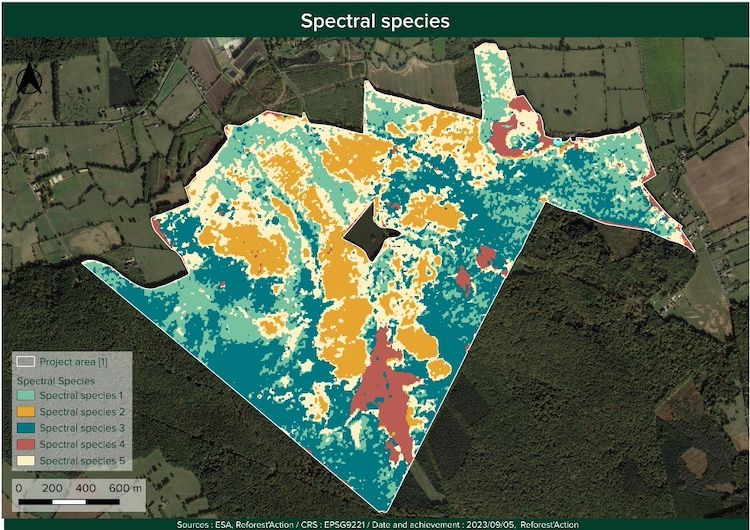
Monitoring plant species diversity in the tree canopy using the spectral species methodology developed by Reforest'Action with The Global Biodiversity Standard.
Exploration and field surveys to refine and complete remote analyses
Monitoring projects in the field is essential. Indeed, only the field can confirm the ecosystem's state of health, its capacity for regeneration, and many impacts that can only be measured on site. For this reason, Reforest'Action has a range of field protocols that can be applied to projects according to their main objectives and risks, and carried out by our own teams or by specialized service providers. Field missions also provide calibration data for remote sensing tools.
Field mission guided by geospatial data analysis to verify ecosystem health and stability and provide adaptive management recommendations where necessary.
Field monitoring techniques for animal biodiversity (environmental DNA, bioacoustics, photographic traps, naturalist inventory) to improve the quality of wildlife habitat within the project.
Field measurements of actual tree growth (from which the carbon stored in their biomass can be calculated), which can be accompanied by measurement of soil carbon stock by laboratory analysis.
Soil samples analyzed in the laboratory to study the soil's textural balance, nutrient availability, mineralization capacity and biological activity - the foundation of its natural fertility.
A set of tools to assess and monitor the project's impact on communities, through employment, training, community projects or food production, for example.